Based on discussions with breeders and agronomists, this guide was developed for those without prior experience using UAVs in small plot trials.
Manual data collection in outdoor small plot research trials is labor intensive and logistically challenging. The sheer number of plots often forces agronomists to settle for cursory field observations. Yet the demand for efficient and accurate phenotyping only grows as new technologies becomes available in response to the need for superior crops.
Fortunately, it is now possible for anyone with a consumer-grade UAV, RGB camera, and a laptop to rapidly collect high resolution field maps and valuable metrics that can supplant manual stand counting and height estimation -- while adding new measurements such as vegetation indices, canopy cover, and more.
The purpose of our guide is to show you how to succeed with UAV’s in agronomic research without relying on third party pilots, data analysis services, or on-farm internet access. It doesn’t matter what kind of drone or camera you have - this will help!
Topics include:
UAV types and selection
Accessories
Basic camera settings
Field preparation
Automated flight for field mapping
Suggested flying height and image resolution for data extraction
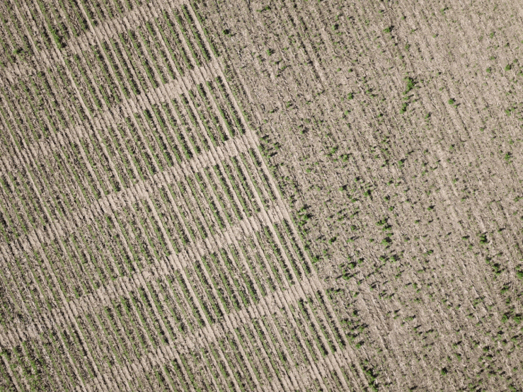
UAS-captured images of a soybean field trial with 80% overlap, suitable for mapping
The use of aerial imagery has long been envisioned as a means for quickly collecting data in field research, thus overcoming some of the temporal and physical constraints of ground-based observations. However, it was not until the introduction of UAS (unmanned aerial systems, consisting of UAV/drone plus digital camera and GPS receiver) and improved batteries that routine imaging of field trials became realistic.
Unfortunately, the potential of UAS in small plot research was oversold by purveyors of hardware who ignored the computational challenges. Until recently, this task required extensive knowledge of GIS (geographic information systems) and access to specialized software tools -- usually several separate packages for image stitching, gridding, and data extraction steps. As a result, many forward-thinking breeders and contract researchers have been disappointed, and their UAVs shelved.
The good news is that it may be time to dust off your drone! It is now possible for anyone to program their UAV for automated flight, capturing high-quality images, and perform stitching/gridding/data extraction -- all with a reasonable investment in hardware and software.
Contact us for your free copy of the complete guide today!
.