
RAW IMAGES TO PLOT METRICS
Stand Counts
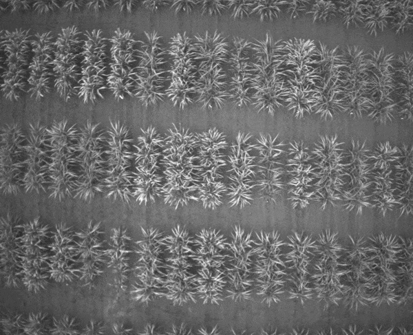
Phenix makes it possible to count every plant from drone imagery in crops such as corn. Benefits:
-
Saves the time & hassle of getting into fields
-
Lowers labor/travel expenses
-
Eliminates human error and reliance on sampling methods
Corn stand counts with Phenix. White crosses are single plants, blue indicates doubles, and red minuses correspond to skips
Count Every Plant!

RAW IMAGES TO PLOT METRICS
Canopy Level Insights: Coverage, Growth, Color, Height
-
Percent Vegetation Cover
-
Early Season Growth/Vigor
-
Vegetation Color related to stress, fertility differences, flowering, maturity
-
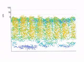
Canopy height: 3D reconstructions and vegetation height above ground level

Top: Plot Clip from a soybean field trial Below: 3D Point Cloud generated from overlapping 2D images of the soybean plot.
Multi-Spectral Image Processing:
Simple & Fast!
Frames (1-5): Original green, blue, red, red-edge, and near-infrared images from a popular multispectral camera; (6) corresponding composite image aligned at the sub-pixel level using Phenix with lens distortion correction and dewarping algorithms applied.
If you need multispectral imaging, we have your back. Generating vegetation indices is a breeze in version Phenix 2.2
-
Automated Image Sorting
-
Sub-pixel image alignment & merging
-
Easily generate multispectral vegetation indices including NDVI & NDRE
Trusted by a Global Client Base


Hear It from Our Customers

"Learning Phenix went really smoothly. I picked it up quickly and it became something very easy to do. We shaved off about a month of traveling for stand counts!"
Damon, Technology Manager, Contract Research
